The North Australia and Rangelands Fire Information (NAFI) service, www.firenorth.org.au based at Charles Darwin University, has become an important free, publicly
available, service that provides critical support to government and industry such that it cannot be terminated without significant negative
consequences - and its funding ends on June 30, 2020. The service has been funded for the last seven years by the unit within the former Federal Department of Environment and Energy that administered the Savanna Burning carbon methodologies. This group
can no longer pay for a service that is used by many more people than the Savanna Burning carbon projects.
Longer term funding and governance arrangements are required and it is proposed these be determined in a three year collaborative project with other
fire data providers and end-users. Help in securing this funding is needed from industry and government groups who have a stake in the service.
What does the NAFI service provide that other services do not?
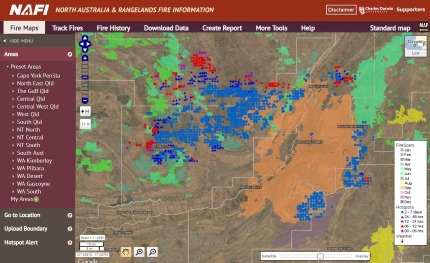
1. Broadscale, accurate fire histories. The service is the sole producer of satellite-based maps of burnt areas (fire scars) that are
uniformly accurate across most of the Australian rangelands (below) making them the only fire scar maps that can be used to produce reliable
fire histories useful for fire management that extend across this region - particularly in the north (shaded area) where annual aerial and image-based validation has
shown that the NAFI fire scar mapping is accurate across this area (more details).
As outlined below, these frequently updated fire histories are important for rangelands fire management.


2. A widely-used, free, publicly available web-portal focused on the land and fire managers of the rangelands. The
extensive fires across the rangelands are largely managed by pastoralists, Indigenous land managers and park rangers who often use fire as a tool for
managing their land. These are distinctive groups who operate outside of fire agencies. Fire agencies, however, are also major users of the service in the
rangelands areas. NAFI is the only major fire data provider with a web-portal that displays the fire scar data, a cleaned-up dataset of active fire locations,
and a range of digital tools, all focused on the needs of these groups. The tools include a report function that uses NAFI's reliable fire histories to quantify
fire patterns in a given area.
The interface and tools of the NAFI web portal firenorth.org.au (below) are developed using feedback
from end-users. The reliable fire scar data are a guide to fuel levels in the path of the fires and these are frequently updated along with the
hotspots enabling better management of active fires in the rangelands. The widespread use of this portal by different groups produces better cooperation
on fire management.

The reliability of the fire scar mapping stems from the frequent overpasses of the satellites used, combined with the skill and knowledge of
fire scar mappers who edit automated mapping to produce uniformly accurate fire scars despite continual changes in landscapes and cloud cover.
The mappers are based in the regions they map, so they have a good knowledge of those landscapes.
Charles Darwin University also provides links to a national and international network of research and technical expertise that allows innovation
to continually improve the fire scar mapping processes.
How widely used is the NAFI service?
The combination of a uniquely useful fire history and website has seen the NAFI service become the main fire data service used by fire managers across
the vast but sparsely populated rangelands. With widespread severe fire conditions across Australia in recent years, NAFI usage has dramatically increased and will see
almost 10 million map requests in 2019.

How is the NAFI service useful for on-ground fire managers?
NAFI's fire scar maps are frequently updated throughout the fire season and the hotspots are automatically updated every few hours dependent on satellite passes.
Combined with the longer fire histories and other tools this allows rangelands fire managers to effectively plan for and manage active fires across most of
the rangelands - which explains the widespread usage. This widespread usage of a shared web-portal then helps the different fire managers battling fires in a
region to cooperate on monitoring and responding to wildfires as they are all looking at the same set of maps.
NAFI's longer term fire histories are also used to help plan prescribed burning and, along with reporting tools, are used to assess progress made in
fire management.
The end result of this usage is improved fire management, better protection of infrastructure and fodder, income for the Savanna Burning
projects, reduced greenhosue gas emissions and better protection of natural and cultural values (see costs and benefits below).
How is the NAFI service useful for Government agencies?
Managers of government lands in northern Australia (National Parks, Defence lands) use the NAFI fire scar data for fire planning and fire management, Fire Agencies
that need to operate in the rangelands use the NAFI fire scar data for planning and because they need to cooperate with the community on rangelands fire management,
benefit from NAFI which aids this cooperation. The income generated by the Savanna Burning projects, which is underpinned by NAFI, saves Government expenditure on
Indigenous health.
How is the NAFI service useful for emissions reduction?
The NAFI service has been used to provide fire scar data for measuring emissions under the Federal Government's Savanna Burning emission reduction
methodologies since their inception, and there are good reasons for this:
Uniformly accurate fire histories across the methodology area is important. If any current or potential project areas have
significantly inaccurate fire histories this will produce a level of unfairness between methodology participants and is likely to expose
the methodologies to reputational damage.
Regular display via the NAFI website and the manual editing process produce a trusted product. Being able to test the fire scars,
against their own observations and the hotpots, as the fire scars accumulate in their local areas, and being able to suggest corrections to the mapping,
produces a high level of trust in the fire data among the fire managers and industry involved in the Savanna Burning projects. This is important
as low levels of trust can be corrosive and lead to reputational damage for the methodologies.
What are the costs and benefits of the NAFI service?
The benefits significantly exceed the costs and most benefits are associated with the public good.
Costs. The NAFI Service will require around $750K a year, plus annual increments to track rising costs, to run sustainably for the three year
period FY 2020/21 - FY 2022/23. This covers a number of increased costs: upgrades needed for the servers and databases; implementing new processes to cover for the retirement
of a key satellite; increased website managements costs due to increased usage; and added mapping costs for the southern Qld rangelands.
Currently NAFI receives around $500K a year as minimal interim funding to keep the service operating while a longer-term plan is put in place which is 33% under funding
required from 20/21 onwards. 69% of the $500K costs are in cash from the DoEE methodology unit and 19% are in-kind CDU contributions. Around 80% of the costs are for the production and
management of the fire scar data.

Public good benefits. (a) The GHG emission reductions produced by the Savanna Burning projects (that depend on NAFI) total between 1-2 M tonnes
CO2e per year. (b) The projects are producing social and economic benefits for remote Indigenous and grazing communities (estimated
to be > $100M per year). (c) Various state and federal agencies (fire agencies, Defence Department) are able to save public funds on fire management
related costs by using NAFI. (d) There is robust evidence of reduced wildfire frequency due to ERF projects and therefore the likelihood of improved
protection of natural and cultural values across very large areas.
Private benefits. (a) The ERF projects are earning around $20M a year in carbon credits. (b) Pastoral enterprises are saving significant
costs on fire monitoring and in improved protection of fodder and infrastructure.
What are the consequences of the NAFI service shutting down?
There would be significant negative consequences as there is no easy way of replacing NAFI's current services.
The uniformly accurate fire scar mapping needs to be delivered across large parts of the rangelands often on a weekly basis during the fire season to help land
managers manage fires. The accurate fire scar mapping requires significant skill and knowledge specific to the landscapes being mapped, that NAFI has built up over many years.
This mapping would be difficult for a new provider to provide and would be required immediately after the NAFI service ends.
The NAFI portal is also difficult to replace as it incorporates many features based on feedback from land managers and is continually being modified in response to
this feedback, using networks that have taken years to build.
The regularly updated fire scars and hotpots, together with the background maps and tools of the NAFI portal are now a vital tool used in managing fires across large
parts of the rangelands - and have become part of fire management culture in these areas. Shutting down the service mid-year would not see an adequate replacement emerge
quickly. This would produce serious disruption to fire management during the northern wildfire fire season in the latter half of the year - fire seasons which are becoming
increasingly serious. It would likely produce economic losses, widespread frustration and disappointment for people who are already facing significant challenges.
It would be challenging for new providers to produce the uniformly accurate, validated and trusted fire scars used for the emissions measurement required by the Savanna
Burning projects. The disruption to fire management combined with these challenges would increase the risk of disruption of the Savanna Burning industry, reputational
damage and consequent future economic losses.
Can the NAFI service be improved?
The NAFI service is looking to improve both the data it provides and the way it is delivered.
Higher resolution fire scar mapping provided by satellites such as Sentinel 2 can provide more detailed maps of burnt areas and CDU
is testing a product with one of the leading groups in Australia in this area: the Remote Sensing Centre in the Qld Dept of
Environment and Science. This higher resolution fire scar mapping is already proving very useful for supporting on-ground fire operations in particular regions.
However, such products cannot yet produce uniformly accurate mapping across the savannas at a reasonable cost - mapping that could be used for cross-continental
fire histories and emissions measurement. A recent meeting of the world's leading fire scar mappers, the 4th Global Wildfire Information System (GWIS) and GOFC-GOLD
Fire IT meeting in Rome, Italy, highlighted the NAFI mapping and confirmed there are no new international products available that can be used in the short term to
provide similar uniformly accurate fire histories. Improvment of the current NAFI mapping used to produce these fire histories is being planned
but any replacement mapping will need to be thoroughly tested as any significant deviation from uniform acurracy and the frequent updating involves significant
risk to the industries that rely on it.
The website and delivery methods can also be substantially improved given they have had very limited development funding for several years.
What's the business plan going forward?
The business plan for the NAFI service involves two components:
Provision of basic fire data that is used by all fire managers and is publicly funded. An example of this basic service is the NAFI map with recent fire scars
and hotpots that you land on when you enter the site. This service helps protect life, property and infrastructure assets along with natural and cultural assets.
Because this basic service is so widely used across jurisdictions, across sectors and by the public and private sectors alike, securing funding from all these users
is difficult. Putting this basic service behind a paywall would likely do more harm than good as one of the key benefits of the basic service is that anyone who
manages fire can use it. Even if you pay for the service and use it to help manage fire on your patch of land, if your neighbour does not pay and struggles to manage
fire, those fires could then spread onto your land.
Provision of specialised fire data services and industry-specific products funded by industries, agencies and businesses. An example
of these services would be more advanced versions of the fire reports on the NAFI site. Such reports and analyses are becoming increasingly important for planning and
assessing fire and land management and can be targeted at particular users and limited to boundaries.
Summary: What are we asking for?
While significant public good benefits are generated for low cost, and while a broad range of fire managers across the Australian rangelands including government and significant
industries, depend on the continued operation of the NAFI service there is currently no Federal funding available that the service can draw on. The DoEE
methodology unit's support for NAFI, which has covered most of its costs for the last seven years, will end on June 30, 2020. The unit can no longer guarantee
support for a service which it is not specifically tasked to fund and which provides such broad benefits beyond the Savanna Burning GHG reduction projects.
For the last two years we have been working with the Federal Government and other NAFI stakeholders to secure more broad-based ongoing funding. To effectively implement longer term
funding, the role that the NAFI service can best play alongside the other fire data providers for the rangelands, and the institutional and governance arrangements
around the provision of these data need to be sorted out. We cannot do this on the current minimal funding.
The NAFI Service requires $750K a year to operate and with the support of the northern pastoral sector we are currently trying to secure funding for this project from the Federal Government.